 |
 |
 |
 News Around the Republic of Mexico | October 2005 News Around the Republic of Mexico | October 2005  
Hurricane Causes Floods in Western Mexico
 Jorge Barrera - Associated Press Jorge Barrera - Associated Press


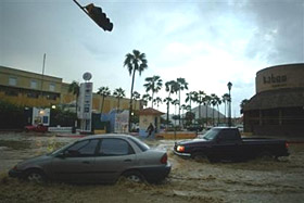
| | Cars drive through flooding in downtown Cabo San Lucas as hurricane Otis passes 130 miles south west Saturday in Baja California, Mexico. (AP Photo/Guillermo Arias) |
The outer bands of Hurricane Otis lashed the coast of western Mexico Saturday as the storm crawled toward the Baja California peninsula, forcing hundreds of families to evacuate their homes and flooding roads in this resort city.

Weakening somewhat, the storm was still expected to come ashore Sunday night at hurricane strength. It was churning about 135 miles west of the southern tip of Baja with sustained winds of 85 mph late Saturday night, drifting north at about 3 mph, the U.S. National Hurricane Center said.

Forecasters expect Otis to skirt Cabo San Lucas and move ashore along a sparsely populated stretch of desert far north of here.

The Category 1 hurricane was expected to produce rain accumulations of 3 to 6 inches over the central and southern peninsula through Monday, with isolated maximum amounts of 10 inches over the higher terrain of central Baja, the hurricane center said.

Rainfall associated with Otis could affect the southwestern United States early next week, forecasters said.

Narciso Agundez, governor of Baja California Sur state, ordered emergency personnel to the community of Comondu, as well as tourist-friendly Lorteo and Mulege, closer to where the center of Otis was likely to hit land. He asked soldiers to help evacuate the islands of Magdalena and Margarita, off the coast of Comondu.

Periods of strong winds and heavy rains were mixed with mostly sunny skies over Cabo San Lucas, giving way to light cloud cover at night.

Mayor Luis Armando Diaz led voluntary evacuations from the city's poor outskirts, where many homes are little more than wood and metal shacks.

About 700 families evacuated to shelters in Cabo San Lucas and more than 200 families evacuated in San Jose del Cabo, a nearby tourist destination to the northeast. There were also small-scale evacuations in Miraflores and Santiago, slightly further north.

But many of those in shelters were expected to return to their homes soon, as the widespread flooding they were bracing for never came.

Mexico declared a state of emergency to help cope with heavy rains in five communities, including Cabo San Lucas.

A hurricane warning was in effect for much of the peninsula's Pacific Coast, from Agua Blanca north to Puerto San Andresito and officials issued a tropical storm watch further northward.

Extended forecasts showed the storm weakening as it moved across the sparsely populated Baja California peninsula, then bringing rains to parts of western Texas and southern Arizona by early next week.

Otis was the 15th Pacific storm of the season. Unlike powerful Atlantic storms such as Hurricanes Katrina and Rita, Pacific hurricanes tend to do less damage because they make landfall less frequently.

Like their Atlantic counterparts, Pacific storms are given names that correspond to the alphabet.

Also Saturday, the season's 20th tropical depression was drifting toward Mexico in the western Caribbean, prompting the government to issue tropical storm warnings for the Yucatan Peninsula.

The depression was centered 80 miles east of Tulum and about 95 miles east of Tulum and about 95 miles southeast of Cozumel, according to the U.S. hurricane center. It was moving west at 6 mph.

The system had sustained winds of 30 mph, but could become a named tropical storm before making its expected landfall on the eastern Yucatan later Saturday or Sunday, according to the center. | 
 | |
 |


