| | |  News Around the Republic | October 2008 News Around the Republic | October 2008 
Tropical Storm Marco Forms in Gulf of Mexico
 CNN News CNN News
go to original
Miami, Florida - The Atlantic hurricane season's 13th tropical depression, which formed Monday in the Gulf of Mexico, has strengthened into Tropical Storm Marco, the National Hurricane Center said.
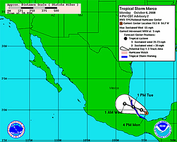
In a 5 p.m. update, the center said Marco was in the south-central Bay of Campeche with maximum sustained winds of 65 mph (105 kph).
The Mexican government issued a hurricane watch Monday afternoon for the Gulf Coast, from Cabo Rojo southward to Veracruz. A hurricane watch means hurricane conditions, including maximum sustained winds of at least 74 mph, are possible within 24 hours.
In addition, a tropical storm warning was issued from Cabo Rojo southward to Punta el Lagarto, forecasters said. The warning means tropical storm conditions, including maximum sustained winds of at least 39 mph, are expected within 24 hours.
As of 5 p.m. ET, the center of Marco was about 100 miles (160 kilometers) east-northeast of Veracruz, Mexico, forecasters said. It was moving west-northwest at near 9 mph and was expected to continue doing so over the next day.
"On the forecast track, the center will be near the coast of Mexico within the warning area late tonight or early Tuesday," the hurricane center said Monday.
"Some strengthening is forecast during the next 24 hours, and Marco could approach hurricane strength as it nears the coast," forecasters said.
Marco was relatively small, however, with tropical storm-force winds extending up to 30 miles from its center.
The storm is expected to dump up to 4 inches of rain across the southern Mexican states of Veracruz, northern Oaxaca and Tabasco, with isolated amounts of up to 6 inches possible in some areas.
The Atlantic hurricane season began June 1 and ends November 30.
Meanwhile, Tropical Storm Norbert is strengthening off Mexico's Pacific coast, The Associated Press reported.
The storm is expected to near southern Baja California by the weekend, but it's likely to have hurricane force, according to the AP. |
|
| |