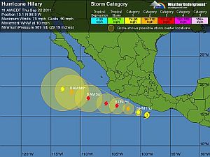
Puerto Vallarta, Mexico - Tropical Storm Hilary has strengthened in the Pacific on the south central coast of Mexico and is now a Category 1 hurricane. It is anticipated to pass along Cabo Corrientes on Saturday. However, depending on how the storm develops, the Banderas Bay region could begin receiving rain, wind and high surf as early as tomorrow.
Hilary's sustained maximum winds this morning are near 75 mph (110 kph). The U.S. National Hurricane Center says Hilary could become a major hurricane by Saturday.
A tropical storm warning is in effect for Mexico's Pacific coast from Lagunas de Chacahua to Punta San Telmo. A tropical storm watch is in effect for west of Punta San Telmo to Manzanillo.
Hilary is centered 140 miles (225 kilometers) south of Acapulco, Mexico, and is moving west-northwest near 10 mph (17 kph).
Keep your eye on the storm's movement and development at the National Weather Service's National Hurricane Center.
NATIONAL WEATHER SERVICE UPDATE:
Thursday, September 22 8 pm PDT
Hilary has rapidly intensified to a Category Four Hurricane and the maximum sustained winds have increased to near 135 MPH (215 KM/H) with higher gusts. Some additional strengthening is possible on Friday, but most likely, there will be some fluctuations in intensity during the next day or so.
WIND: Tropical storm force winds are affecting portions of the coast within the warning area. these winds are expected to spread Westward along the coast during the next 24 to 36 hours.
RAINFALL: Hilary is expected to produce rainfall amounts of 3 to 5 inches across Southern Guerrero and Southern Michoacan in Southern Mexico with isolated amounts of 10 inches possible.
SURF: Swells generated by Hilary are affecting portions of the coast of Southwestern Mexico. These swells are likely to cause life-threatening surf and rip current conditions.


