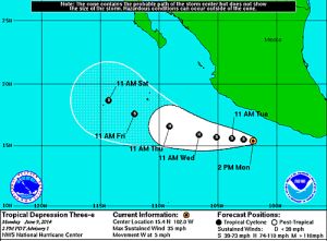
Tropical Depression Three intensified early on Tuesday morning and is now Tropical Storm Cristina in the Eastern Pacific, about 175 miles south-southwest of Zihuatanejo, Mexico.
Wind estimates still show tropical-storm status and satellite data showed minor strengthening this morning. Cristina's movement remains at a westward path but it is moving at a slow pace. Conditions remain favorable for further strengthening as this system moves through a low-shear environment with favorable water temperatures.
Models continue Cristina on a westward path for the short-term and eventually more of a west-northwest path later in the week. The system will likely remain away from land in its travels. Hurricane status will likely be reached over the next couple of days. However, the system will eventually move into drier air and higher shear. Also, Cristina will move into slightly cooler waters as well. All of this will contribute to weakening this storm.
The impacts of heavy rain and stronger winds will remain off of the coast. However, rough surf and rip currents will plague the coasts of Oaxaca northward to Jalisco throughout the workweek.
Keep up with all of the Eastern Pacific Tropical Cyclone activity (provided by NOAA) right HERE on BanderasNews.com.


