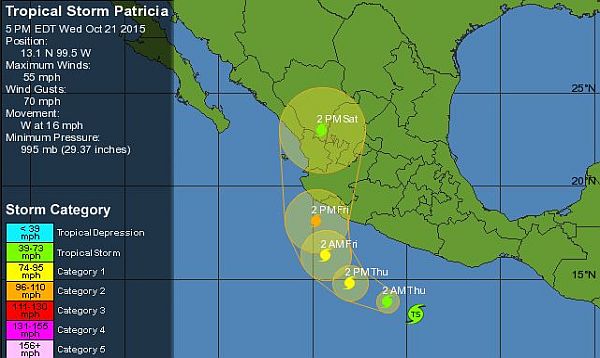
Puerto Vallarta, Mexico - Tropical Storm Patricia is located in the eastern Pacific Ocean off the Mexican coast and is expected to strengthen into a hurricane Thursday. Patricia is forecast to make landfall along Mexico's Pacific coast on Friday, where damaging winds, storm surge flooding and rainfall flooding could all be threats.
Here's the scoop:
• On Wednesday morning, Patricia was located about 320 miles southeast of Acapulco.
• The storm will move parallel to Mexico's Pacific coast before eventually curling northeast towards the west-central Mexico coast where landfall is expected on Friday. Residents and visitors in the Mexico resort cities of Puerto Vallarta, Manzanillo and Acapulco should monitor the progress of this system very closely.
• A hurricane watch has been issued along the Pacific coast of Mexico from Lazaro Cardenas to Playa Perula, including Manzanillo. A tropical storm watch is posted from east of Lazaro Cardenas to Tecpan De Galeana. A hurricane watch means hurricane conditions are possible in the watch area. The watch is issued 48 hours in advance of when the first tropical-storm-force winds are expected to arrive.
• The threat for wind damage and storm surge will depend on how much Patricia intensifies between now and when it makes landfall. Regardless of how strong it becomes, Patricia may dump 6-12 inches (locally 20 inches) of rain over the Mexican states of Jalisco, Colima, Michoacan and Guerrero. Life-threatening flash flooding and mudslides are possible.
• Assuming Patricia makes landfall as a hurricane, it would join just four other eastern Pacific hurricanes to do so this late in the season dating back to 1949, according to weather.com meteorologist Jonathan Erdman.
Once this system moves inland, mid-level moisture and energy from it may get pulled into the south-central US. This may add more fuel to a heavy rain and flooding threat in Texas and nearby states this weekend.
Click HERE for the latest updates.


