 |
 |
 |
 Editorials | Environmental | June 2006 Editorials | Environmental | June 2006  
Mexico Creates Border Nature Reserve
 Mark Stevenson - Associated Press Mark Stevenson - Associated Press


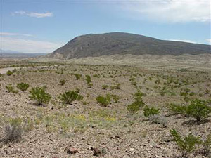
| | The Sierra de San Vicente in northern Mexico is seen in the distance from inside Big Bend National Park in Texas. The nearby Rio Grande serves as a natural border and Mexico plans to build a nature reserve along 600 miles of the river. (USGS) |
Mexico City – Mexico is creating an environmental reserve about 30 feet wide and 600 miles long on the Texas border, a “green wall” to protect the Rio Grande from the roads and staging areas that smugglers use to ferry drugs and migrants across the frontier.

Much of this border zone is remote and inhospitable – generally too rough to hike through unless you're a black bear or a pronghorn, species that have flourished in the area's deserts and mountains.

And that's the way Mexico wants to keep it.

While the proposed Rio Bravo del Norte Natural Monument is only about 30 feet wide, it will connect two large protected areas south of the river. When a third nature reserve, known as Ocampo, is created this year, the protected areas in Mexico will form a “wall” of millions of acres of wilderness, matching Texas' Big Bend parks foot-by-foot along the border.

“This stretch of border is the safest one we have. It's safe because it has wilderness on both sides,” said Carlos Manterrola, who heads the environmental group Unidos Para la Conservacion.

Big Bend National Park has had some problems with migrant and drug trafficking, but Superintendent John King says extending protected areas on either side of the border will likely keep the problem from getting worse.

“When you have a roadless area, you make it more difficult for these activities to happen,” King said.

The strip protects a much longer stretch of riverbank, from just downstream of the Texas border town of Presidio to the outskirts of Laredo, Texas, raising the possibility of still larger reserves that will serve as biological corridors, encouraging four-footed traffic but making it exceedingly difficult for humans to pass.

In other border areas where U.S. reserves aren't fully matched in Mexico – such as Arizona's Organ Pipe Cactus National Monument – primitive roads and ramshackle hamlets have sprung up on the Mexican side to provide supplies and staging areas to illegal border crossers. They have then overrun U.S. wilderness areas.

As the U.S. puts up more fencing near cities and popular crossing zones, migrants will likely be looking for new routes in remote areas.

That happened with the Mexican hamlet of Las Chepas, which became a hub for undocumented border crossers. The problem got so bad that Mexican authorities – at the urging of New Mexico Gov. Bill Richardson – bulldozed 31 buildings to discourage them from being used as a smuggling haven.

Now, Mexico is working on yet another “mirror” border reserve, to be announced this summer in an area known as the Janos grasslands, roughly west of Las Chepas and across from the Alamo Hueco Mountains and Big Hatchet Mountains Wilderness areas in New Mexico's boot heel region.

Law enforcement is a problem at many Mexican parks, but if well policed, the 1.2 million acres of the proposed Janos wilderness area could not only protect one of the largest prairie dog populations in North America, but also present a natural barrier to smugglers moving deeper into the wild as border security tightens.

Mexican ranchers and environmentalists applauded the Rio Bravo del Norte proposal, which was published Monday, starting a 30-day comment period. Along with the Ocampo wilderness, it will protect several pine- and oak-clad mountains often described as “sky islands,” temperate mountaintop enclaves divided by seas of heat-seared desert or grassland.

“This would close the circle,” said Jesus Armando Verduzco, a 73-year-old ranch owner from Ocampo. “Perhaps later, we could do a bit of hunting, eco-tourism, preserve it for humanity.”

Some environmentalists say this policy of establishing nature preserves along the border could be a more effective alternative to the walls and “smart” fences being considered in Congress.

“The whole idea that people are coming up through wilderness and roadless areas, and that's simply not the case,” said David Hodges, policy director of the Sky Island Alliance. “People have a tendency to stay near roads, because they don't get lost and that's where they get picked up. ... It would be disastrous to put roads through these areas.” | 
 | |
 |


