|
 |
 |
 Editorials | Environmental | April 2008 Editorials | Environmental | April 2008  
Forecaster Raises Atlantic Hurricane Number
 Michael Christie - Reuters Michael Christie - Reuters
go to original


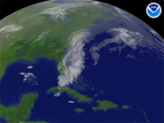
| | Storm systems are seen over the eastern United States in a handout satellite visualization taken April 7, 2008. (Reuters/NOAA) | | |
Miami - The noted Colorado State University hurricane research team last week raised the number of tropical storms and hurricanes it expects to form in the upcoming Atlantic storm season.

The team founded by forecasting pioneer Bill Gray increased its outlook by two tropical storms to 15, and by one hurricane to eight, compared with a long-term average of around 10 and six, respectively, for a storm season.

"Current oceanic and atmospheric trends indicate that we will likely have an active Atlantic basin hurricane season," said Gray in a statement.

Of the eight hurricanes predicted by the forecasters for the six-month season starting June 1, four were forecast to become major storms with winds of at least 111 miles per hour (178 kph). Major, or intense, storms, which rank from Category 3 to Category 5 on the five-step Saffir-Simpson scale of hurricane intensity, are the most destructive.

"Based on our latest forecast, the probability of a major hurricane making landfall along the U.S. coastline is 69 percent compared with the last-century average of 52 percent," said Gray protege Phil Klotzbach, who now leads the CSU team.

"We are calling for a very active hurricane season this year, but not as active as the 2004 and 2005 seasons."

The United States was struck by just one minor hurricane in the 2007 Atlantic storm season and escaped unscathed the year before.

But 2005 produced a record 28 storms, including Hurricane Katrina, which swamped the city of New Orleans, killed around 1,500 people on the U.S. Gulf Coast and caused $80 billion in damages.

The 2004 season saw Florida struck by four hurricanes in a row.

The two seasons made financial markets acutely aware of the threat the massive storms pose because of their potentially devastating impact on U.S. and Mexican oil and natural gas production in the Gulf of Mexico, on commodities like oranges and cotton and on cities and people.

WARM WATER

While 2007 was quiet for the United States, it was painful for the Caribbean, Central America and Mexico. Last year's hurricanes Dean and Felix were the first two Atlantic hurricanes since records began in 1851 to make landfall in the same season as potentially catastrophic Category 5 storms.

The CSU team said the conditions favoring an active hurricane season in 2008 included a continuing though likely weakening La Nina in the Pacific, warm sea surface temperatures in the tropical eastern Atlantic and the likelihood of weak trade winds.

The La Nina weather phenomenon -- an unusual cooling in the Pacific -- tends to result in conditions that favor hurricanes in the Atlantic, while its opposite, El Nino, creates vertical wind shear that tears nascent hurricanes apart.

Gray's team said it expected to see a moderation in La Nina conditions but did not expect a transition to an El Nino event during the hurricane season.

It said in its report that it had not raised the expectation for the number of hurricanes as high as some of its calculations had suggested it do, because of uncertainty over how long La Nina conditions would persist.

"However, if current trends in the Atlantic persist, there is a possibility that the forecast could be increased more in early June," the report said.

(Editing by Tom Brown and Philip Barbara) | 
 | |
 |


